Ram Setu Bridge
The stories of our mythology have a geographical connection as well. Ram setu bridge is one such tale. It is also called Adam’s bridge and is closely related to both Sindhu and Christian mythologies. It is a chain of limestone shoals between Pamban island and the Rameshwaram island. So let’s explore it.
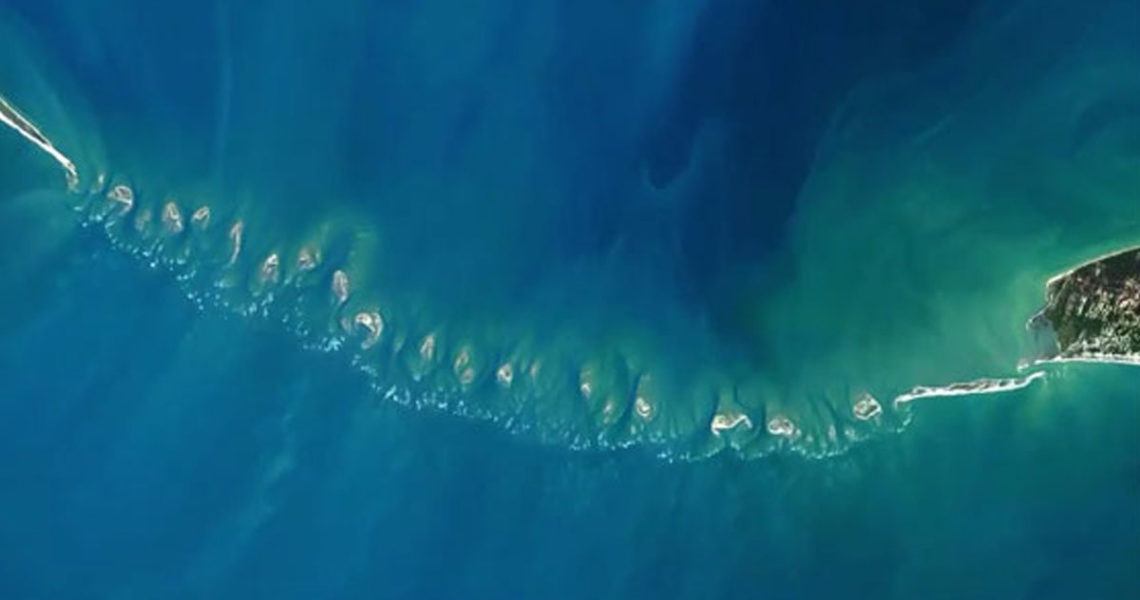
History: It is located off the south-eastern coast of Tamil Nadu, India, and Mannar Island, off the north-western coast of Sri Lanka. Geological evidence suggests that this bridge is a former land connection between India and Sri Lanka. The bridge stretches around 48 kms separating the Gulf of Mannar from the Palk Strait. Some of the regions are dry and the sea in the area rarely exceeds 1 metre (3 ft) in depth, thus hindering navigation. It was reportedly passable on foot until the 15th century, when storms deepened the channel. According to temple records, Ram setu was completely above sea level until the cyclone of 1480 when it broke. It was initially first mentioned in the epic Ramayana by Valmiki. According to the epic, Lord Rama and his monkey troops built this bridge by rocks to travel to Lanka and rescue Sita. It was during 7th to 3rd century BCE. However, the Western world first came to know about it from the Book of Roads and Kingdoms by Khordhabheh. According to Islamic roots, Adam fell in a mountain of Sri Lanka. He then travelled by this route to India from the garden of Eden. Thus the name Adam’s bridge. It’s a chain of shoals from the Dhanuskoti tip of the Indian Plamban Island ending in Sri Lankan Mannar Island. Pamban Island is semi connected] to the Indian mainland by the 2-km-long Pamban Bridge. This forms one of the shortest borders of the world. In Ramayana, Ramasetu, Rameshwaram, Dhanushkodi, Devipattinam are mentioned. The Shallow waters of the Ram setu bridge is a hindrance for navigation. Smaller boats were found here. Larger ocean-going vessels from the west have had to navigate around Sri Lanka to reach India’s eastern coast. According to geographer Rennell a navigable passage could be maintained by dredging the strait of Ramisseram. In 1823 Sir Arthur surveyed the Pamban canal. Geological evidence indicates that a land connection bridged this in the past, and some temple records suggest that violent storms broke the link in 1480. Cotton suggested that the channel could be dredged to enable passage of ships, but nothing was done until 1828 when Major Sim directed the blasting and removal of some rocks. The Indian culture assigns Ram setu to supernatural origins. It is believed to be constructed by the monkey army of Lord Rama under the engineering of Nala to reach Lanka to kill Ravana and rescue Sita. This bridge is also called Nala Setu. According to Tamil nationalists and Bharatidasan State University, the carbon dating the beaches roughly matches the dates of Ramayana, its link to the epic needs to be explored. The structure dates back to 3500 years ago. The investigation determines that the land between Ramanathapuram and Pamban were formed due to the longshore drifting currents. About 3,500 years ago, the currents moved in an anti-clockwise direction in the north and clockwise direction in the south of Rameswaram and Talaimannar. In the same study, carbon dating of some ancient beaches between Thiruthuraipoondi and Kodiyakarai shows the Thiruthuraipoondi beach dates back to 6,000 years and Kodiyakarai around 1,100 years ago. According to the Geological Survey of India, the structure is impossible to be naturally formed because of the presence of a loose sand layer under corals for the entire stretch. Coral typically forms above rocks. However, NASA and certain Indian scientists rejects this proposal. According to the Archaeological survey of India, no evidence has been found to declare the structure to be man made. The Archaeological survey of India stated that there is no historical proof of the bridge being built by Rama. It must have naturally formed.
Geography: Many debates have followed regarding the Ram Setu. It is sometimes considered it to be formed by the process of accretion and rising of the land, while others summarised that it was established by the breaking away of Sri Lanka from the Indian mainland. The friable calcareous ridges later broke into large rectangular blocks, which perhaps gave rise to the belief that the causeway is an artificial construction. It is mostly a series of parallel ledges of sandstone and conglomerates that are hard at the surface and grow coarse and soft as they descend to sandy banks. According to IISRO’s remote sensing data, Adam’s Bridge comprises 103 small patch reefs lying in a linear pattern. It has sand cays and deep channels. There are number of studies focused on the formation of the Ram Setu. In one study it’s proposed that it is formed from crustal down warping, block faulting, and mantle plume activity. In another theory it’s said that it is formed by continuous sand deposition and the natural process of sedimentation leading to the formation of a chain of barrier islands related to rising sea levels. It can also be due to old shoreline developing into coral reefs. In another account, longshore currents moving in an anticlockwise direction in the north and clockwise direction in the south of Rameswaram and Talaimannar which creates the sand in a linear pattern, along the current shadow zone between Dhanushkodi and Talaimannar with the later accumulation of corals over these linear sand bodies. According to some geologists crustal thinning theory, block faulting and a ridge formed in the region owing to thinning and asserts that development of this ridge augmented the coral growth in the area and in turn coral cover acted as a ‘sand trapper’. According to the Tombolo model, a constant sediment source and a high unidirectional or bi-directional longshore current raised reef in southern India probably results from a local uplift. Over 100,000 years this canal has acted as a land connection between India and Sri Lanka which According to some ornithologists like Bruce Bheeler supports vicariance model for speciation in some birds of the Indian Subcontinent. According to GSI the sand dunes between Dhanushkodi and Adam’s Bridge started forming about 500–600 years ago. However, in another study it’s suggested that coral samples gives radiocarbon age of 4020 years.
Sethusamudram shipping canal project: The government of India constituted nine committees before independence, and five committees since then, to suggest alignments for a Sethusamudram canal project. Land passages instead of cutting Adam’s Bridge because of the several advantages of land passage cutting the passages. According to the 2005 approval, a channel is expected to cut 400 km off the voyage around the island of Sri Lanka. This proposed channel’s current alignment requires dredging through Adam’s Bridge. Political parties like BJP and RJD oppose this on grounds of dredging along a religious canal. The political parties and organizations suggest alternate alignment for the channel that avoids damage to Adam’s Bridge. However, According to Minister Baalu the project was economically viable and environmentally sustainable and that there were no other alternatives. Some organisations completely oppose this project on economic and environmental grounds and claim that proper scientific studies were not conducted before undertaking this project. This is due to impacts on area’s ecology, marine wealth, loss of thorium deposits and risk of damage due to tsunamis.
Whatever may be the reasons of this formation, it definitely has an ancient root which we all must appreciate. Hope you had a great reading. Keep following us to keep updated. We will be back soon. Stay safe and connected.